On Crete Island, Greece, floods have become frequent and catastrophic under climate change. In the case study of Giofyros River, the city of Heraklion, to complement the Integrated Flood Management (IFM) model, a social component has been added. The new model is based on conflict resolution between human activities and hydrological/hydraulic laws. This model uses the observation that historically, water-human interactions have been and remain contradictory, i.e. at the same time conflictual and cooperative. To increase flood security, firstly the conflicts are assessed and analyzed; secondly, by unifying the opposite water-human interactions, a dialectic flood resilient solution is obtained.
Background
A historical review indicates that the way humans manage water-related issues reflects their relationship with nature. This has continuously oscillated between two opposites: conflict and cooperation. In ancient times, nature and water were respected as divinities. At the same time, water was hostile because it originated catastrophic floods. Humans have conceived their interaction with nature as a balance of power between natural forces and their capacity to regulate them. After the second industrial revolution (1870-1970), they felt able to dominate nature. The construction of the pharaonic Hoover Dam in 1935 is a milestone for the engineering profession to serve human interests by modifying and regulating nature. The water-human relationship is also reflected in the water resources management model that has been in constant temporal evolution. In the late 20th century, the IFM model was promoted as the state-of-the-art tool integrating water resources, land use, and risk management. In this case study, we claim that the IFM model is anthropocentric and technocratic, and because it neglects the social dimension it is unable to achieve high flood resilience.
To illustrate the eristic-dialectical model, the case study focuses on the Giofyros River, Crete Island, Greece. Giofyros is one of the biggest streams of this Mediterranean island that outfall the Aegean Sea through the western suburbs of the city of Heraklion. On 13th January 1994, a devastating flood occurred in the Giofyros basin, after a series of the following events.
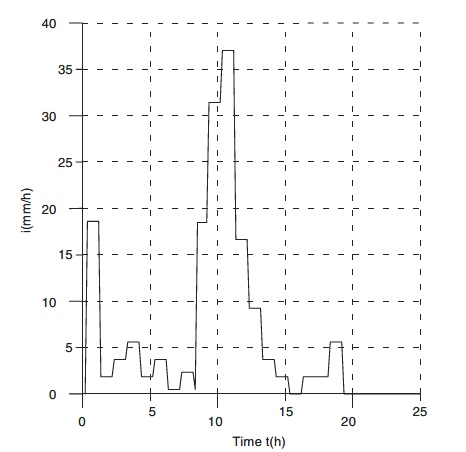
Rainfall. The total rainfall recorded on the day of the flood was about 185 mm, equal to about half of the mean annual precipitation in the region of Heraklion. A maximum rainfall intensity of 37 mm/h has been recorded, and in 6 hours, which is about the retention time for the Giofyros basin, total rainfall of 143 mm has been recorded.
Soil. The soil was almost completely saturated because rainfall of a light intensity had persisted several days before the critical storm.
Deforestation and the removal of several hectares of vineyards during the months preceding the storm have increased the intensity of the flood.
Many houses near the coast were flooded and damage was evaluated at several hundreds of thousands of Euros. The most important effect of the flood was the damage caused to the city’s wastewater treatment plant. Many of the plant’s reservoirs, made of concrete, were rendered unserviceable or completely destroyed by the force of the incoming water.
In our case study, a new eristic-dialectical approach is suggested to complement IFM by adding a social component to increase flood resilience. The new model proceeds in two steps: (a) firstly, possible conflicts between stakeholders’ activities and natural laws are assessed (Eristic Analysis), and (b) secondly, by unifying the opposite objectives through a dialectical approach a flood resilient solution is achieved (Dialectical Resolution).
Actions taken
This case study has been originated from a catastrophic flood that happened in January 1994 in Heraklion, the capital city of Crete Island. The city authorities were deeply concerned by the severity of the flood that damaged many private houses and public property in the coastal area of the city.
Figure 0. Flood hydrograph (13 Jan. 1994)
The main negative impact of the flood has been recorded in the city’s Waste Water Treatment Plant (WWTP) which was under construction at that time in the vicinity of the river’s bed. The Giofyros River, although relatively small and getting dry for several weeks in summer, is one of the most important rivers on the island. The main geomorphological characteristics of the Giofyros catchment are the following:
- Total area: 189 km2
- Max hydraulic route: 31 km
- Max altitude: 1000 m
- Mean altitude: 353 m
Alternative measures to increase the resilience to floods have been applied in two different scales, such as the: (1) Giofyros River catchment or regional scale, and the (2) sub-catchment or local scale at the river’s flood plain. The IFM model has been used to combine: water resources management with land use and the engineering flood risk analysis. The latter has been applied to develop a multi-objective risk-based approach through the following steps: (1) identification of flood hazards, (2) flood risk quantification, (3) consequences of risk, and (4) risk management. The main objectives or criteria taken into consideration were: (1) Economic, (2) Environmental, and (3) Social. The steps undertaken for multi-objective planning of flood control alternatives were the following:
- Setting up a set of alternative measures, which include structural and non-structural infrastructure of flood protection;
- Evaluate the impact matrix, i.e. assign rates to each specific objective, corresponding to each particular action; and
- Rank the alternative actions, using professional experience or an appropriate multi-objective analysis technique.
Different techniques available for multi-criteria decision-making:
- ELECTRE I to III
- Compromise programming
- Goal programming
- Sequential multi-objective optimization
- Game theory.
Alternative measures for floodplain protection:
(1) Regulation of the downstream cross-section of the Giofyros River to increase its hydraulic capacity. Due to some constraints (existing bridges), the maximum hydraulic capacity has been evaluated as the 20-year flood (Q=300m3/s).
(2) Design of multi-purpose reservoirs to retain a substantial volume of the critical flood and serve for agricultural irrigation. Two reservoirs of different capacities were proposed:
- 2.1 a 28 x 106 m3 reservoir with an earthen dam of about 70 m in height
- 2.2 a smaller reservoir with a total capacity of 15 x 106 m3
It should be noted that the net annual water balance for the catchment was estimated at 20 x 106 m3, although the maximum volume of a 50-year flood is about 5 x 10⁶ m3.
(3) Use of a stormwater detention basin network distributed over the catchment. The principal function of the system could be to reduce the peaks of the flood hydrographs. At the same time, significant volumes of water may be retained locally for agricultural purposes. The design of the detention basin reservoirs (i.e. their size and site) could be adequate to sustain floods of T=30, 50, or 100-years return period.
For the decision making by the public authorities in cooperation with the research team led by Prof. Ganoulis, two basic issues have been critically discussed: (1) the fact that the flood risk cannot be completely eliminated; (2) the cost of implementing alternative measures increases with the increase of the targeting flood resilience.
Given the limited economic means of local authorities, the implementation of a network of detention reservoirs of T=30 years return period has been chosen as a trade-off of the alternatives.
Outcomes
The social component in the new Eristic-Dialectical Integrated Flood Management (EDIFM) model is an addition to the IFM model that has common elements with the IWRM approach. It proceeds with the following steps
(1) River Basin Authorities (RBAs)
IFM plans are developed by the RBAs at the river basin scale. RBAs are responsible for collecting data, assessing the existing natural end ecological status of water bodies, and setting up the River Basin Management Plans (RBMPs). In the EDIFM model, RBAs have additional duties for including the stakeholders in the flood management process. A strong consultation with stakeholders is added and the conflictual interaction between water users and water resources is considered.
(2) Joint Action Plan (JAP)
In the EDIFM model, the pressure-response process that is the main component of the IWRM model is complemented by a stakeholder consultation aiming to set up a JAP. The aim of the JAP is to establish a participatory program for collecting hydrological and socio-economic data, analyzing existing conflicts of interest, implementing dialectical solutions for conflict resolution, and registering the progress made. In the JAP, to identify the flood risks not only the natural hazards but also anthropogenic pressures on water resources are taken into consideration by analyzing the conflicts between social activities and the hydrological/natural laws. The new water-human integrated approach defines a dialectical relationship to nature by taking into account nature’s rights and reinforcing environmental equity.
(3) Conflict Eristical Analysis (CEA)
In the CEA process, conflicts are classified into a) conflicts between humans and nature (anthropo-natural), and b) social, economic or political conflicts between stakeholders (anthropo-socio-economic). In the EDIFM model, anthropo-natural conflicts are recognized when man violates natural laws.
(4) Dialectical Conflict Resolution (DCA)
As the most crucial part, it is based on a dialectical reflection and a profound knowledge of natural laws to suggest a conflict resolution based on the unity of opposite issues.
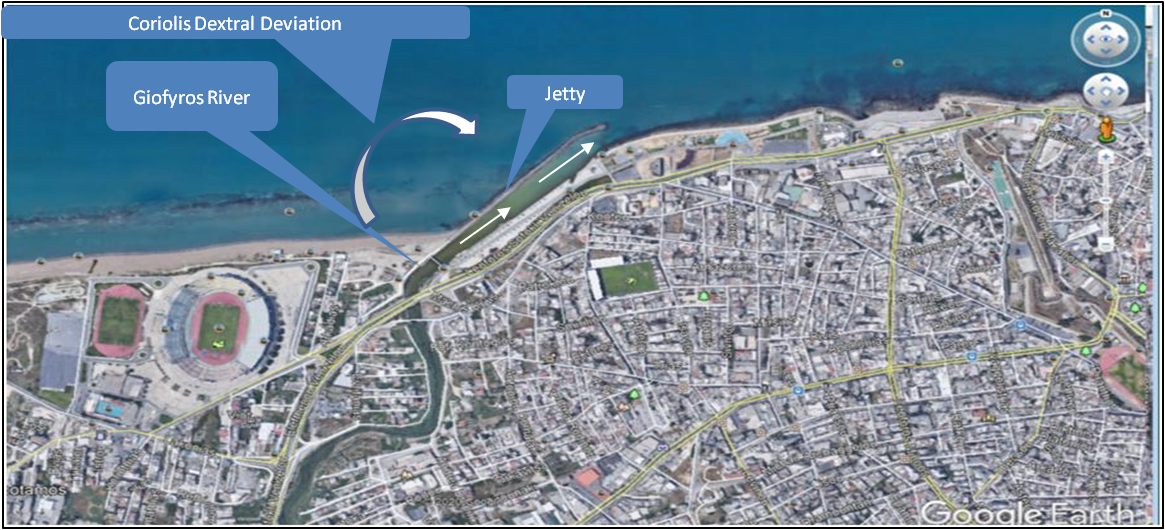
Figure 1. Giofyros outflow
The expert team of the Aristotle University of Thessaloniki was designated by the city’s authorities to suggest measures of flood control. The EDIFM model has been applied as follows:
1) A JAP has been established in cooperation with the Regional Agency for Eastern Crete Development (OANAK) and local stakeholders.
2) Possible conflicts between natural laws and human activities have been analyzed. Two main natural/hydrological/hydraulic laws have been identified to be violated during a flood:
(a) The Hydraulic Law: the water overflows the river banks when the river’s flow rate (e.g. 300 m3/s for T=20 years) exceeds the flow capacity of the river bed (Ganoulis, 2003).
(b) The Coriolis Phenomenon in the Northern Hemisphere: due to the Earth’s rotation and negligible tidal forces, the outflow of Mediterranean rivers shows a dextral deflexion. As shown in Figure 1, by a dextral diversion of the Giofyros mouth, Coriolis inertial forces can facilitate the transportation of sediments from the river’s mouth into the sea.
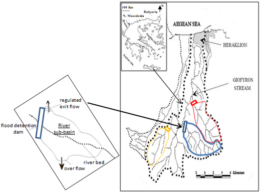
Figure 2. Giofyros basin
3) Dialectical resolution:
(a) To resolve the hydraulic conflict, i.e. a flood exceeding the river’s flow capacity, alternative solutions are described in the previous section. A dialectical solution in harmony with the hydraulic law consists of building a few shallow flood detention dams across the Giofyros basin (Figure 2). In contrast to flood retention reservoirs, a flood detention reservoir is complemented with an outlet pipe up to a certain altitude. During the flood, the peak of the floodwater is accumulated in the detention reservoir and the remaining floodwater is safely evacuated into the river.
(b) To maintain the Coriolis effect for solid transportation, an earthen jetty has been constructed into the sea to protect the dextral deviation of the river’s mouth (Figure 1).
Lessons Learned
Activating stakeholders in the IFM model
Increase flood resilience by adding a social component to the IFM model. This has been achieved by the Eristic-Dialectical IFM model that proceeds in two steps (1) assessing conflicts between stakeholders and hydrological/hydraulic laws and (2) resolving these conflicts by unifying opposite issues and obtaining environmental equity.
Flood detention reservoirs
Flood resilience at the watershed level increases by retaining only the peak of flood instead of storing the total flood volume. Flood detention reservoirs are adequately designed among the river’s sub-catchments to avoid the accumulation of tributary flows that may cause an overflow downstream. Water volumes stored in detention reservoirs can be used for irrigation
Solid transportation by Coriolis forces
Coriolis forces were used to facilitate solid transportation from the river’s mouth into the sea. This can be achieved by preserving the natural dextral flow deviation with an inclining jetty. The inertial forces prevent possible obstruction of the river’s mouth and reduce maintenance costs. This is illustrated in the case study and was proven reliable.
Keep urban streams uncovered
Urban water streams, such as the Giofyros River, can enhance green areas, reduce temperature increase due to climate change and absorb air pollution. Public authorities use to cover water streams because of lack of water flow in summer and activation of mosquitos’ colonies. Flood detention reservoirs can provide sufficient water to sustain in summer ecological flows.
Flood Governance
Hydro-Governance is the integration of water management and policy in the political field. It is exercised at different levels, such as National, Regional and Local. Flood Governance at the local level, consisting of the city elected authorities, the public organism for water management (OANAK), and the University team as scientific advisor, was proven very efficient in practice.
 Case study