Effective flood risk mitigation requires assessing costs and benefits of alternatives of intervention. The European Floods Directive requires to produce risk maps, as a basis of Flood Risk Management Plans. Damage evaluation is a critical step of this process, due to the lack of consolidated practice in the literature and the technical domains. By allowing scientists and practitioners working together, MOVIDA developed a procedure, and supporting IT tools, embracing state of art knowledge on damage modelling, for the appraisal of flood damage in the Po River District. The procedure was applied in areas at significant risk within the district to prioritize mitigation strategies.
Background
Flood damage assessment is a non-consolidated challenging practice for European River District Authorities, which, however, are required to produce flood damage and risk maps to accomplish with the so-called Floods Directive (FD). Such maps are, in fact, the key element for the evaluation of risk mitigation measures to be implemented in Flood Risk Management Plans (FRMPs). Indeed, the effectiveness of a measure is evaluated by comparing its cost to the damage avoided thanks to its implementation, which represents its benefit.
The development of FRMPs ideally requires consistent and comprehensive damage assessment, for all items which are located in potentially flooded areas, and all kinds of expected impacts, being they related to the direct contact with flood water (i.e., direct damage) or being an indirect consequence of it (i.e., indirect damage, like business and services interruption or contamination). Nonetheless, a quantitative/monetary evaluation of damage is crucial when there is a need to prioritize interventions, especially over large geographical areas, and impacts in the present and project states must be compared.
In practice, the goal of exhaustive damage assessment is currently not achievable due to the inhomogeneous levels of development of (and, in some cases the lack of) damage models.
Paucity and low quality of georeferenced data for characterising exposed items further limit the range of damage models that can be implemented for the assessment. In fact, we deal with scarcity of institutional databases (i.e., data are often stored in commercial repositories), legal impediments in the use of data, fragmentation of information among different databases, and their inadequacy in supplying information required as inputs of the damage models; obsolescence of information is sometimes a problem, with data referring up to ten years ago.
At the EU level, lack of models and data is reflected in the tools presently implemented to assess flood damage within the scope of the Floods Directive. Evaluations performed by the European Commision, whose results are summarised in Figure 1, highlight how different levels of analysis can currently be achieved for the various items exposed to floods, where differences strongly depend on the availability of national/local tools and required input data.
Nonetheless, a gap exists between state of art and practice in flood damage modelling; in fact, despite several damage models have been developed, for many regions of the world, flood risk analysis is still mostly focused on the hazard component of risk. The main factor hampering the implementation of available damage models by institutions and technicians is the lack of simple and immediate tools, whose execution does not require specific expertise by end-users. It is often the case that more reliable modelling tools are based on advanced skills and technologies which are usually lacking in the professional world.
Actions taken
In order to define shared and feasible cutting-edge solutions for flood damage assessment in the Po River District (the biggest river district in Italy, located in North of the country) where, so far, damage and risk were evaluated only in qualitative terms and mostly according to expert-driven rules of thumbs, the Po River District Authority launched in 2020 the MOVIDA (Modello per la Valutazione Integrata del Danno Alluvionale) project. The project involved the partnership of 8 Italian universities and the National Research Council and it was partly funded by the same Authority and partly by the consortium of partners.
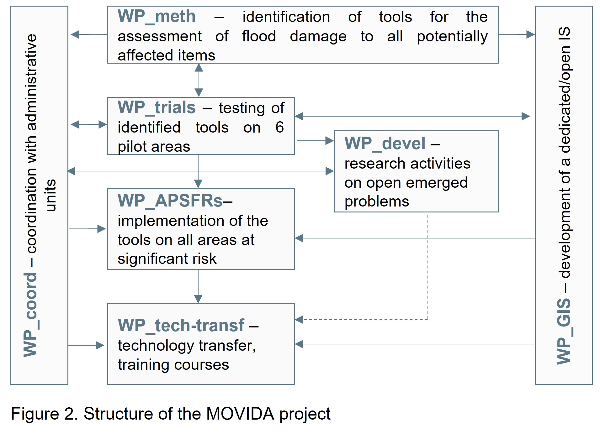
To reach the project aim, a case-study, iterative approach was implemented (Figure 2), in which the focus of the analysis was the five categories of exposed assets included in the Floods Directive (i.e., population, infrastructures, economic activities, environmental and cultural heritage, and na-tech sites). Suitable models for the assessment of flood damage were first identified among those available in the literature and suitable for the context under investigation, or newly developed (WP_meth). Such tools were then tested in 6 pilot areas, characterised by different data availability as well as susceptibility to be damaged in case of flood (WP_trials); this step allowed to tune a damage assessment procedure that is flexible and usable in the different implementation scenarios, which can occur at the district scale. Once validated, the procedure was implemented in all the areas of potentially significant flood risk (APSFRs) in the district (WP_APSFRs), with the final aim of updating flood damage maps. The whole process allowed to identify more urgent research needs and to carry out related research with specific application to a few areas in the Po District (WP_devel).
A significant effort was dedicated to the identification of the main input data for the analysis that were chosen according to specific requirements: (i) being institutional (if possible), and (ii) available for the whole district, in order to guarantee the consistent applicability of the procedure (and then of its results) in all the areas of the district. With respect to this, the use of satellite data was also investigated, being them useful in providing homogeneous and updated information concerning actual landscape all over the river basin at a proper scale.
The identification of both modelling tools and data has been accomplished with the support of the main (public) institutions responsible for flood risk management in the district, namely the Regional Authorities (WP_coord). Their involvement was crucial for validating and limiting the set of alternative available methods in relation to the objective of the analysis. In fact, a model can be very useful for one purpose and not for others; discussion among scientists, practitioners and stakeholders is valuable to clarify whether a damage model is useful or not. Likewise, institutions’ involvement was fundamental in the definition of new modelling tools wherever an expert evaluation was required. Finally, the role of institutions was important in the identification, provision, interpretation, and elaboration of the data at the base of the assessment, as most of such data are produced by the same organizations.
A dedicated open Information Systems that allows to implement the procedure in a semi-automatic way was also developed (WP_GIS) to support institutions and, more in general, non-expert users in the adoption of the procedure. Specific training modules have been finally designed and released to the above-mentioned institutions to facilitate the implementation of MOVIDA and the usage of the Information System (WP_tech-transf).
Outcomes
The first product of MOVIDA is a geographic database where all the main input data for damage assessment are stored in a homogeneous way. Moreover, when available data proved to be highly heterogeneous and fragmented, new informative layers were produced, as in the case of cultural heritage, natural environment, and strategic buildings. The database is at the disposal of the Po River District Authority and of the several institutions responsible for flood risk management in the district.
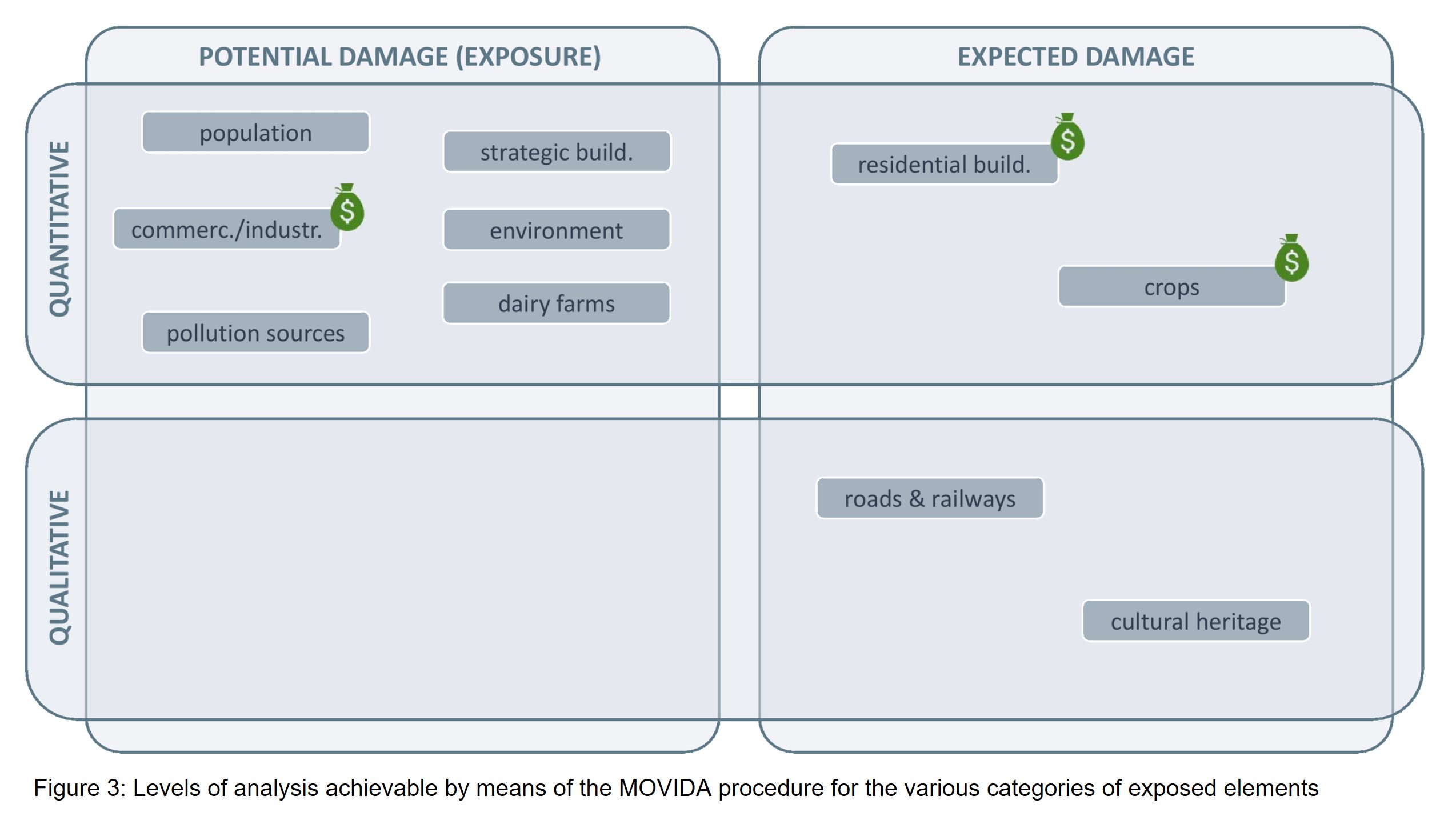
Second, a procedure for flood damage assessment was developed. The level of analysis achieved varies with the considered type of assets, according to the inhomogeneous level of development of damage models (Figure 3). In detail, we identified models for estimating direct damage in monetary terms for residential buildings and a limited number of crops; for economic activities and livestock we estimated instead the exposed economic value. With respect to people, critical infrastructures, cultural and environmental heritage, we assessed their amount within the potentially flooded areas, and classified them according to some vulnerability features. For the case of cultural heritage, given its importance in the Italian context, an ad-hoc procedure was developed to estimate damage, even though in qualitative terms (i.e., low to high damage classes). Indirect damage estimation was instead not feasible, although an attempt was made to estimate impacts of roads and railways interruption (see also Table 1 for a comparison with other Member States). In this context, the necessity to compare inhomogeneous quantities having different meanings (e.g., damage versus exposed value) and metrics (e.g., economic loss, physical damage, qualitative damage) was tackled by implementing a participative process, which led to the definition of a qualitative index, representative of the total expected impact of a hazard scenario.
The third product is the open Information Systems ISYDE that includes ad-hoc developed GIS-based models, enabling the implementation of the MOVIDA procedure in a semi-automatic way, also by non-expert users. The use of ISYDE is supported by a user guide and training videos.
The final product of MOVIDA is then a comprehensive set of tools supporting decision-making on flood risk mitigation based on expected risk scenarios, overcoming the limitations of current approaches based only on hazard knowledge. In this regard, in the context of the 2021 revision of the FRMP of the Po District, the MOVIDA tools have been used by project partners and institutions of the district to update expected damage scenarios in all APSFRs. The procedure was further applied to support the definition of high priority mitigation strategies within the plan and it is currently used to evaluate the effectiveness, and then the sustainability, of individual mitigation actions.
The procedure and its supporting tools still present room for improvement. However, we think that the change in paradigms performed in the MOVIDA project (towards an analytic assessment of flood damage) is an irreversible process, especially considering advancements brought within decision making. The partnership between academia and institutions, which should be replicated in the future, also in other countries, proved to be successful to this aim; funds dedicated to flood resilience within the Next Generation EU programme represent a real opportunity of action.
Lessons Learned
MOVIDA proved that the close collaboration between researchers and practitioners allow to find a balance between scientific rigour and the need of technical improvement. MOVIDA led to feasible solutions to emerged problems and, together, to the transfer of scientific knowledge; the commitment of several research institutions, working together and sharing expertise, was undoubtedly an added value.
The integrated approach of MOVIDA is unique for Italy. Still, it was conceived to be replicated in other areas/at different scales; such a joint way of working can then be adopted also in other river districts. Moreover, considering the harmonisation required to Member States in the implementation of the FD, a discussion among scientists, practitioners and stakeholders at the EU level is needed.
The integrated approach implemented in MOVIDA would be beneficial not only for damage assessment related problems but also for challenges linked to other aspects of flood risk management (like climate change), as well as other natural hazards.
MOVIDA highlights that implementing damage models in real practice is the most proper way towards their standardisation. Damage models cannot be validated by laboratory tests: their validity and transferability must be assessed through application. Damage assessment criteria deeply depend on scope; thus scientists, practitioners and stakeholders must confront each other, finding shared practices.
Gaps between academia and technicians can be bridged by (a) an inclusive/participatory approach in the definition of methodologies, and (b) the transferring of such methodologies into simple tools, that do not require specific expertise to be implemented. To this aim GIS technology has proved to be very supportive.
 Case study